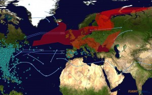
This real-time graphic, provided by Sabre Flight Explorer, shows the impact that the volcanic ash plume is having on flight routes. The graphic was taken at Monday at 19:00 UTC.
Red/Orange Zones depict the extent of the volcanic ash plume as forecast by the latest volcanic ash advisory (1900 UTC) prepared by the Icelandic Met Office and issued by the VAAC, London. Straight Blue Lines show the daily published flight routes that are designated for eastbound and westbound trans-oceanic flights.
* Routes A and B: westbound flight routes from northern Europe – currently extremely limited due to the volcanic ash zone
* Routes C and D: westbound flight route from southern Europe – currently in heavy use as they avoid the volcanic ash zone and originating extremely far west
* Routes Y and Z: eastbound routes into Europe – only two routes in operation and extremely southern as they are guaranteed to avoid the volcanic ash zone
Blue Arrows show the high altitude global jet streams. Airplane graphics indicate the airlines currently flying


